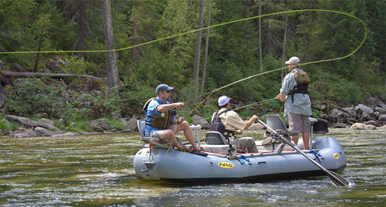
Trail Head Missoula Montana
Trail Head Missoula Montana Welcome to the Trail Head, Missoula MT!

Mon-Fri
9:30am-8:00pm
Saturday
9:00am-6:00pm
Sunday
11:00am-6:00pm

A Specialty Outdoor Gear Store providing
Western Montana with quality products, service,
and information for over 25 years!
Downtown Missoula: 221 E. Front St. Missoula, Montana 59802 1-406-543-6966
montana recreation information
Western Montana Recreation Information
Skiing & Winter Recreation Rock Climbing Recreation missoula montana outdoor conditions
Specialty Outdoor Gear
 Outdoor Gear:
  Climbing/Caving
  Hiking/Camping
  Backpacking
 Skiing:
  Alpine Touring
  Telemark
  Backcountry
  Cross Country
  Accessories
 Snowshoeing
 Clothing:
  Men's
  Women's
 Footwear 
 Kid's Gear
 World Travel
 & Commuter
 Racks
 Pet Gear
 Books/Mags
 Videos
 Maps
 Rental:
  
Summer
  
Winter
 Boating:
  Canoes
  Kayaks
  Rafts
  Safety
  Clothing
  Accessories
  Boating Tips
 About Us
 Groups We
 Support!

 Outdoor
 Resources
 & Links

 Repair
 Shop Prices
 Our Vendors!
 Gear Check
 Lists

 Wedding &
 Bridal
 Registry

 Currency
 Exchange
 Rates
 Shipping:
 UPS
 USPS
 Staff Login
 Home
On the Water
Call Us for Other Trip Ideas

   (River flows, Maps, Gear Lists, Rental)
Quick Trips Day Trips Overnighters Multi Day Whitewater Surf Spots
Quick Trips Flat Water
French Town Pond French Town State Park located
8 miles east of Missoula
Fee Access   
(No dogs allowed)
Quick Trips Moving Water
Clark Fork River:
Sha-ron to McCormick Park
Seven miles Watch out for irrigation diversion weir at upstream end of Jacob's Island
Clark Fork River:
McCormick Park to Kelly Island
Six miles  
Bitterroot River to
Clark Fork River:
MacLay Flat to Harpers Bridge
Eight miles  
Bitterroot River:
Lolo to Buckhouse Bridge
Five Miles  
Bitterroot River:
Buckhouse Bridge to Maclay Flat
Three Miles  
Blackfoot River:
Angevine to Bonner
Four Miles  
Day Trips
Canoe Trail:
Clearwater River to Seeley Lake Ranger Station (3 miles)
I-90 East to Hwy 200 East, Go 33 miles to Clearwater Junction (Large Cow) turn left, Go .8 miles past Seeley Lake Ranger Station (take out) to the put in. There are signs on the Highway. Nice mellow float ends in Seeley Lake, can hike (1.5) the canoe trail back to vehicle, great birding opportunities.
Harpers Lake I-90 East to Hwy 200 East, Go 33 miles to Clearwater Junction (Large Cow) turn left, Go 1.5 miles & turn left. Two lakes- Harper North is a small pothole lake, Blanchard (South) is the Clearwater River.
Blackfoot River:
Whitacker Bridge to Johnsrud
I-90 East to Hwy 200 East,
Turn left on access road.
Class II Whitewater Water
Bitterroot River:
Florence to Lolo
12.5 Miles  
Overnighters
Flat Head River:
Buffalo Bridge to
Sloan Bridge
Call Us for Maps and Details Nice beginner float in the Mission Valley, beware of long shuttle
(Need tribal recreation permit)
Clark Fork River:
Superior to
St. Regis
Call Us for Maps and Details Camping available at Sloway
Multi Day
Northfork Flathead River Call Us for Maps and Details Great float along the
western boundary of
Glacier National Park
Missouri River
Fort Benton to Judith Landing
Call Us for Maps and Details Famous Lewis and Clark
stretch, white cliffs etc.
Missouri River:
Judith Landing to Robinson Bridge
Call Us for Maps and Details Beautiful stretch through
Montana's Badlands
Missouri River:
Holter Dam to Cascade or Ulm
Call Us for Maps and Details Great Canyon Scenery
Yellowstone River:
Anywhere!
Call Us for Maps and Details Longest undammed river in the lower 48.
Whitewater
Blackfoot River Class I & II
Seasonal due to river levels
Call Us for Details
Check Blackfoot River flows
Clark Fork River:
Alberton Gorge
Class II-III
Just east of Missoula on I-90,
Put in at Cyr, Exit 70
Call Us for Maps and Details
Check Montana River flows
Alberton Gorge Map
Lochsa River, Idaho Class III-IV
Located on Hwy 12
just over Lolo Pass
Call Us for Details
Check Idaho River flows
Canoe Surf Spots
(For Whitewater kayak surf spots go to Board of Missoula)
Blackfoot River:
The Ledge
Located just east of Johnrud Park on the Blackfoot River corridor Canoe surfing between
3500-6000 cfs.
Check the River Flows!
Blackfoot River @ Bonner
Clark Fork River:
Brennan's Wave
Located near the Higgins St. Bridge next to the Wilma Theatre
Canoe surfing
Check the River Flows!
Alberton Gorge @ St.Regis
Clark Fork River:
Alberton Gorge
Triple Bridges
Located just east of Missoula on I-90,
Exit 66
Canoe surfing between
4000-6000 cfs.
Check the River Flows!
Alberton Gorge @ St.Regis
Quick Trips Day Trips Overnighters Multi Day Whitewater Surf Spots
specialty outdoor gear missoula montana

| Climbing/Caving | Hiking/Camping/Backpacking |
| Skiing: Alpine Touring, Telemark, Backcountry Touring, Cross Country, Avalanche Safety, Accessories |
| Snow Shoeing | Travel/Commuter | Books/Mags | Videos | Maps | Racks | Men's Clothing |
| Women's Clothing | Kid's Gear | Pet Gear | Footwear | Rental: Summer/Winter | About Us | Groups We Support |
| Boating: Canoes, Kayaks, Rafts, Safety, Clothing, Accessories, Adhesives, Tips |
| Outdoor Resource & Links | Repair | Our Vendors | Gear Check Lists | Bear Aware | Wedding Registry | Exchange Rates |
| Montana: Ski Resorts, Glacier National Park, Yellowstone National Park, National Forests, Montana Road Reports |

Trail Head
221 E. Front St, Missoula, Montana 59802
1-406-543-6966          F-406-543-8440

Email Us: infoattrailheadmontana.net